improve formatting
Source Link

I have a task of classifying spatial data from a geographic information system. More precisely, I need a way to filter out unnecessary line segments from the CAD system before loading into the GIS (see the attached picture, colors for illustrative purposes only).

enter image description here

The problem is that there are much more variations of objects than in the picture. The task is difficult to solve in an algorithmic way.

I tried to apply a bunch of classification algorithms from the Scikit-learn package and, in general, got significant results. GradientBoostingClassifier and ExtraTreeClassifier achive an accuracy about 96-98%, but:

This accuracy is achieved in the context of individual segments into which I explode the source objects (hundreds of thousands of objects) After reverse aggregation of objects it may turn out that one of their segments in each object is classified incorrectly. The error in the context of the source objects is high

significant computational resources and time are required for the preparation of the source data, and calculation of features for classifiers

it is impossible to use the source 2d coordinates of objects in algorithms, but only their derivatives

  • this accuracy is achieved in the context of individual segments into which I explode the source objects (hundreds of thousands of objects) After reverse aggregation of objects it may turn out that one of their segments in each object is classified incorrectly. The error in the context of the source objects is high

  • significant computational resources and time are required for the preparation of the source data, and calculation of features for classifiers

  • it is impossible to use the source 2d coordinates of objects in algorithms, but only their derivatives

I tried to find good examples of use deep neural networks for this kind of tasks / for spatial data, but I only found articles that are quite difficult to understand about the use of such networks for point clouds classification, and some information on geometric deep learning for graphs. I do not have enough knowledge to adapt them for my case

Can someone provide me good examples of using neural networks directly with 2d coordinates and, maybe, good articles on these theme written in simple language?

Thanks

I have a task of classifying spatial data from a geographic information system. More precisely, I need a way to filter out unnecessary line segments from the CAD system before loading into the GIS (see the attached picture, colors for illustrative purposes only).

enter image description here

The problem is that there are much more variations of objects than in the picture. The task is difficult to solve in an algorithmic way.

I tried to apply a bunch of classification algorithms from the Scikit-learn package and, in general, got significant results. GradientBoostingClassifier and ExtraTreeClassifier achive an accuracy about 96-98%, but:

This accuracy is achieved in the context of individual segments into which I explode the source objects (hundreds of thousands of objects) After reverse aggregation of objects it may turn out that one of their segments in each object is classified incorrectly. The error in the context of the source objects is high

significant computational resources and time are required for the preparation of the source data, and calculation of features for classifiers

it is impossible to use the source 2d coordinates of objects in algorithms, but only their derivatives

I tried to find good examples of use deep neural networks for this kind of tasks / for spatial data, but I only found articles that are quite difficult to understand about the use of such networks for point clouds classification, and some information on geometric deep learning for graphs. I do not have enough knowledge to adapt them for my case

Can someone provide me good examples of using neural networks directly with 2d coordinates and, maybe, good articles on these theme written in simple language?

Thanks
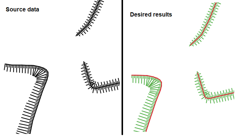
I have a task of classifying spatial data from a geographic information system. More precisely, I need a way to filter out unnecessary line segments from the CAD system before loading into the GIS (see the attached picture, colors for illustrative purposes only).

enter image description here

The problem is that there are much more variations of objects than in the picture. The task is difficult to solve in an algorithmic way.

I tried to apply a bunch of classification algorithms from the Scikit-learn package and, in general, got significant results. GradientBoostingClassifier and ExtraTreeClassifier achive an accuracy about 96-98%, but:

  • this accuracy is achieved in the context of individual segments into which I explode the source objects (hundreds of thousands of objects) After reverse aggregation of objects it may turn out that one of their segments in each object is classified incorrectly. The error in the context of the source objects is high

  • significant computational resources and time are required for the preparation of the source data, and calculation of features for classifiers

  • it is impossible to use the source 2d coordinates of objects in algorithms, but only their derivatives

I tried to find good examples of use deep neural networks for this kind of tasks / for spatial data, but I only found articles that are quite difficult to understand about the use of such networks for point clouds classification, and some information on geometric deep learning for graphs. I do not have enough knowledge to adapt them for my case

Can someone provide me good examples of using neural networks directly with 2d coordinates and, maybe, good articles on these theme written in simple language?

Thanks

Source Link

Suitable deep learning algorithms for spatial / geometric data

I have a task of classifying spatial data from a geographic information system. More precisely, I need a way to filter out unnecessary line segments from the CAD system before loading into the GIS (see the attached picture, colors for illustrative purposes only).

enter image description here

The problem is that there are much more variations of objects than in the picture. The task is difficult to solve in an algorithmic way.

I tried to apply a bunch of classification algorithms from the Scikit-learn package and, in general, got significant results. GradientBoostingClassifier and ExtraTreeClassifier achive an accuracy about 96-98%, but:

This accuracy is achieved in the context of individual segments into which I explode the source objects (hundreds of thousands of objects) After reverse aggregation of objects it may turn out that one of their segments in each object is classified incorrectly. The error in the context of the source objects is high

significant computational resources and time are required for the preparation of the source data, and calculation of features for classifiers

it is impossible to use the source 2d coordinates of objects in algorithms, but only their derivatives

I tried to find good examples of use deep neural networks for this kind of tasks / for spatial data, but I only found articles that are quite difficult to understand about the use of such networks for point clouds classification, and some information on geometric deep learning for graphs. I do not have enough knowledge to adapt them for my case

Can someone provide me good examples of using neural networks directly with 2d coordinates and, maybe, good articles on these theme written in simple language?

Thanks